Though this year’s hurricane season has been relatively calm so far, millions of Texans understand the sudden massive destruction those strong storms can bring.
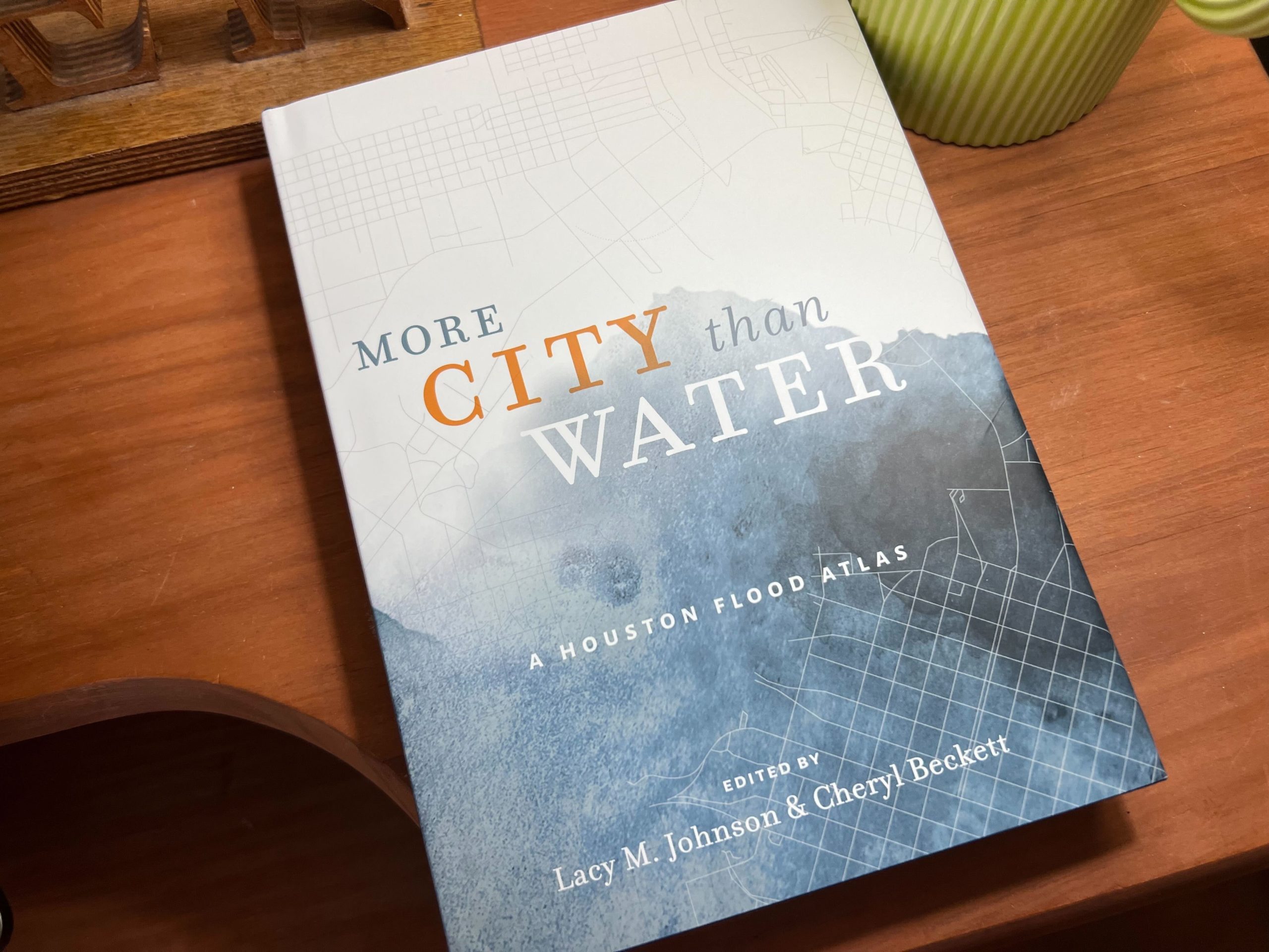
Flooding has long been a devastating result of hurricanes for cities along the Gulf Coast. And in the new book “More City Than Water: A Houston Flood Atlas,” editors Lacy Johnson and Cheryl Beckett tell the story of what it really means when catastrophic flooding affects people in different ways in the aftermath of Hurricane Harvey in 2017.
This transcript has been edited lightly for clarity:
Texas Standard: Lacy, I want to begin with you because you wrote the introduction of this book. Could you tell us a little bit more about the disparity? We often think of hurricanes in a singular sense, but that might obscure more than it reveals.
Lacy Johnson: It’s true. I think we tend to think of a hurricane or a storm as being the weather that falls down and flooding as being equally distributed across everywhere the rain falls. But one of the things that we have learned in the process of doing this work, of working on the Flood Atlas and working on the Houston Flood Museum before that, is that that’s not necessarily true, that flooding maps on to other kinds of disparities. The communities that flood most often are also the ones that don’t have equal access to recovery resources, that don’t have flood insurance. It becomes a kind of self-perpetuating problem.
Cheryl, what made you want to take on this project?
Cheryl Beckett: Well, I think that the idea of making this information accessible in ways – both through a myriad of different essays and also through these maps – can help the city to understand better what resources are needed and what steps need to be taken to try to alleviate some of the problems in the future.
Cheryl, let’s focus on these maps. They’re beautifully illustrated and vivid as well. Could you say more about the decision to go in that artistic direction?
Cheryl Beckett: Well, first, I do want to say that the maps are by the University of Houston’s senior graphic design class. I think that sometimes you see maps that are purely data-driven and they don’t necessarily tell the complete story, not that these maps tell the complete story, but if you can be more expressive where you’re actually looking at this map, and on some level, you get the whole mood and the attitude and the bigger sort of picture in just that one glance, I think it can tell you a big part of that story.
Lacy, tell us more about the writing that you gathered here. Why such a varied collection?
Lacy Johnson: Well, we wanted to hear from a lot of people who don’t typically get to have a place at the table in this conversation or whose voices we may not get to hear from as often. You know, I think when we talk about flooding in Houston, we hear a lot from people who want to build more reservoirs and want to channel the bayous and who think about flooding in terms of infrastructure. And we hear a lot from those folks.
But the people we wanted to create a space to speak were people who had other kinds of experience and expertise, who themselves had experienced flooding and had some really important perspectives on that. People who responded to flooding by creating entirely new organizations, like we have an essay in the collection from some of the founders of West Street Recovery. And those folks created that organization in the face of sort of seeing the kind of inequality that flooding can create and perpetuate in this region.
And these organizations take on a new life of their own, in a sense, in these communities as well.
Lacy Johnson: They really do. And that organization, in particular, I so admire, because they started as just a way to sort of help people muck out their homes and connect people to recovery resources. And in the time since, they’ve become a really powerful advocate in this community for flooding justice, for drainage justice, and for holding decision makers and people who hold on to those purse strings to account for distributing them more equitably.
Flooding justice, drainage justice: I think that sounds somewhat foreign to a lot of people’s ears. But I suppose it would come under the rubric of criminal justice, or no?
Lacy Johnson: Yeah, environmental justice, racial justice. And, thinking about justice more broadly, I can give you an example to describe what I mean. So, I live on the west side of Houston, near the reservoirs. And in my community, the neighborhood flooded during the rain part of Harvey, but flooded worse when the reservoirs were opened and there was that second round of flooding. In that second time, there was sewage and contagion, and everything was in the water. It wasn’t just rain. It’s a fairly affluent neighborhood that I live in, but the homes were ruined. Lots of insurance payments and FEMA payments came out.
And in response to that since Harvey, there is this multimillion dollar infrastructure project to create drainage under the streets, under the city, to move water when it sort of begins to come out of the bayou, away from our homes. But in other parts of the city that are not as affluent, drainage is a ditch only. That’s it. That’s all the drainage that they have. The only protection they have in their homes from flooding is a ditch between the street and their home. And it’s not enough to protect people’s communities, their homes, their memories. There’s an essay in the collection about a woman whose family photographs were ruined and destroyed. And that’s not just memorabilia; that’s history.
Cheryl Beckett: Lacy just alluded to the essay “Trace of a Trace.” The map was done by Manuel Vasquez. In the essay or in the map, you can see this polaroid frame submerged in water and chemicals obliterating that photo. So, as Lacy was alluding to, that idea of not just losing your property, but also your sense of history and all your memorabilia. That’s one that I think was very powerful for me.
What are you hoping readers take away from this book ultimately?
Cheryl Beckett: Well, I hope that when you’re putting together both the maps and the essays, that you have a very much deeper understanding of the whole range of issues. And again, it’s impossible to cover all of them, but that you have a broader range of the issues that affect both the inequality and the infrastructure. My particular visual essay that I worked on, Ombrophobia, what really struck me was I had initially thought that I could map out or draw out every single storm, hurricane or tropical storm that had hit the Texas coast since recorded history, 1850, but what you realize is that it was like this massive tangle.
It was almost 200 storms that have hit in that time, and 40 of them since 2000. So, you realize that this is not a problem that’s going to go away. And in fact, this is a problem that’s going to only get worse over time. And the more ways that we understand it, I think the better we can solve some of the problems.


