Randy Jamieson lives in the River Place development in Northwest Austin – what developers call a “master-planned” community. About 4,000 people live there, and the city of Austin recently annexed it. With its location near Lake Travis, real estate agents pitch the area as desirable for homebuyers looking for “Hill Country” and “Lakeside” views. But Jamieson feels nervous about living there.
“My anxiety goes pretty sky high when it’s hot and dry; we’re in a tinderbox,” he says while sitting in a busy café in a strip mall near his home.
River Place and several communities nearby face some of the highest risk of catastrophic wildfires in the Austin area. And the city of Austin released an audit in late October indicating the city isn’t doing enough to prepare.
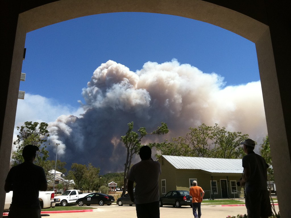
In 2011, Texas was in the middle of a historic drought, and on Labor Day weekend that year, conditions were ripe for wildfires: it was very dry and very windy. Nine major wildfires broke out in several places surrounding Austin. The most significant was the Bastrop County Complex fire, about 30 miles east of Austin. That fire destroyed 32,000 acres, 1,600 homes and killed two people. Closer to Randy Jamieson’s River Place neighborhood, a wildfire in the Steiner Ranch community destroyed more than 20 homes that year.
“We stood on the crest of River Place Boulevard looking across at Steiner Ranch and wondering if the fire was going to continue coming towards River Place,” Jamieson says.
No one was killed in the Steiner Ranch fire. But there’s only one way into the development and one way out, which led to some serious problems with evacuation. Jamieson says it wasn’t until those wildfires broke out that he started to realize the risk of living in River Place.
Later, driving around his neighborhood, Jamieson points out how close homes and businesses are to each other.
“There’s a school … there’s the Austin Christian Fellowship Church,” he says.
He no longer sees the vegetation, steep hills and cliffs common in the area as merely aesthetically pleasing; they’re now, to him, things that could easily fuel wildfires. And like Steiner Ranch, Jamieson’s community is hard to get into and to leave: the main entrance and exit pours onto a notoriously windy and congested road.
“It’s already congestion, but it’s congestion with density waiting for a disaster. … It’s creating one,” he says.
The wildfire outbreak nearly a decade ago served as a wake-up call for the city of Austin. A year later, it established a wildfire division within its fire department with the goal of reducing the risk of wildfire destruction in Austin. To do this, it mapped out Austin’s Wildland Urban Interface – it’s like a flood plain map but for wildfires.
Kari Hines is a Wildland Urban Interface, or WUI, expert at the Texas A&M Forest Service.
“The basic definition is just where human infrastructure meets wildland habitat,” she says. “So anywhere you can have a wildfire burning that comes into contact with human structures – whether that’s houses or critical infrastructure, whatever that could be.”
The WUI pinpoints which part of a city is at the greatest risk for catastrophic wildfire damage. Austin’s Public Safety Commission says 61% of Austin homes, businesses and roads are close to areas that are at risk of wildfire. After the wildfire outbreak in 2011, city leaders discussed adopting citywide WUI codes – like fire codes for buildings, but for wildfires.
“The codes look at how dense an area can be built out to, where people can build structures, what building materials can be used, how you manage your vegetation – both natural vegetation and what you plant around your house,” Hines says. “Access for emergency vehicles is another big one.”
Hines says wildfire codes can help cities more safely develop in wildland areas while accommodating the high risk of wildfire. But Austin has yet to adopt such codes. In the recent audit, the city said putting these codes in place was its No. 1 priority for wildfire prevention. Austin City Council member Alison Alter of District 10 in West Austin says that’s a sign the city could still be doing more to address wildfire risk.
“Austin’s an interesting case: We created a wildfire division and we have some resources that are devoted to it. But there’s a serious question about whether we are doing enough given the hazards that we face,” Alter says.
Alter says there is concern that wildfire codes could cost developers more money. Plus, there’s the unanswered question of how much implementing the codes would cost taxpayers. But she says the cost of not implementing the codes could be even greater.
“We know that the next major wildfire in Austin is not a question of if but when. And we really need to be zeroing in and making sure that we can do everything that we can,” Alter says.
Late last week, a majority of the Austin City Council greenlighted plans for a development of about 20 homes in a part of the River Place neighborhood that faces severe wildfire risk. A spokesperson for the developer says it does plan to build the homes with wildfire codes in mind. Still, no citywide code requires it to do so. But that could change soon: Austin City Council members are expected to consider a proposal for a wildfire code at the end of this year.


